I made bushfire maps from satellite data, and found a glaring gap in Australia’s preparedness

I made bushfire maps from satellite data, and found a glaring gap in Australia’s preparedness
Staff reporterFebruary 23, 2020

GUEST OBSERVATION

On the night of January 9 2020, my wife and I secured our Kangaroo Island home and anxiously monitored the South Australian Country Fire Service (CFS) website for bushfire advice.

After many horrific weeks of bushfires, the winds had again shifted, and the fire front began a slow, nightmarish march eastward into the island’s central farmlands. Official warnings advised that the entire island was potentially under threat.

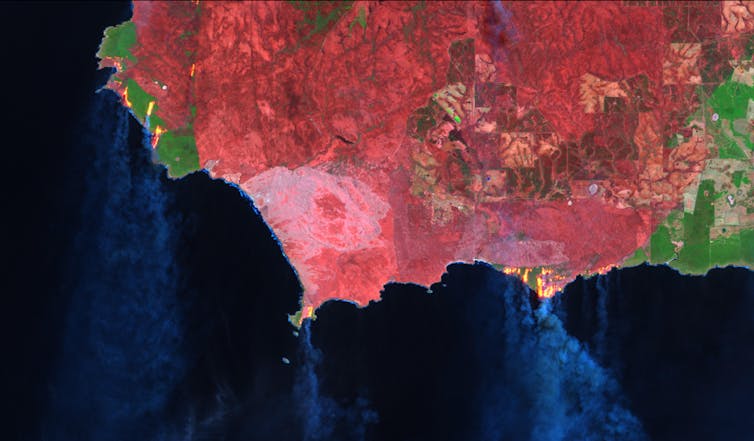
Landsat-8 false colour image of southwest Kangaroo Island, showing active bushfires on January 9, 2020. Landsat-8, Author provided

As my good neighbours and volunteer firefighters headed off to battle the flames elsewhere on the island, I desperately wanted to find a way to help. With no firefighting training, I felt I physically had little to offer. But I reasoned that my skills and training in remote sensing and spatial science could potentially turn satellite information into useful maps to track the fires, in more detail than those provided by the Country Fire Service and Geoscience Australia.

While I was ultimately successful, it wasn’t quite as straightforward as I thought. And what I learned about access to good-quality and up-to-date satellite bushfire information surprised me.

Free satellite imagery is abundant; useful information is not

In principle, there are many good sources of free satellite imagery. But selecting, sourcing, understanding and processing a multilayered satellite image into an accurate burnt area map takes technical know-how that is beyond the reach of the people who need it the most.

We are fortunate to live in a time where satellite images are constantly uploaded to the web, often within hours of acquisition. There are many reputable sources for this information, including NASA Worldview, USGS Earth Explorer, USGS LandLook Viewer, and the Sentinel EO Browser.

These websites are gateways to the world of “big satellite data”, and I quickly found myself on a steep learning curve to efficiently navigate them and find recent imagery.

Once downloaded, the next hurdle I faced was how to process a data-rich satellite image into a meaningful and accurate map of the bushfire area. I scoured the internet for “how to” blogs, academic articles, spatial algorithms, and processing codes; these too are the products of much intellectual investment by global scientists, openly and freely available.

As a spatial scientist, I naturally found all this fascinating. But as a resident of an island under assault from bushfires, I also found it frustratingly time-consuming. I crashed my computer testing algorithms. I maxed out my hard drive. I spent hours on possibilities that turned out to be dead ends.

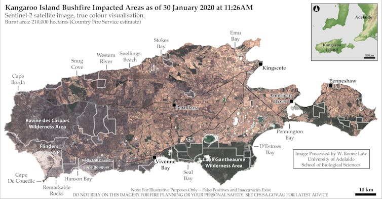
True colour satellite imagery is often the most accessible and easily understood, but it often lacks sufficient detail to clearly identify burnt areas. In this Sentinel-2 true colour image, approximately 210,000 hectares are burnt, but bushfire-impacted areas are barely visible without advanced image processing. Sentinel-2, Author provided

Maps help to fight fires and recover from them

In the end, I produced burnt area maps from Sentinel and Landsat satellite images captured during the fires. I learned that this kind of information can indeed help firefighting and ecological recovery efforts, both during and after bushfires.

Initially I gave the maps to a group of farming friends who had been fighting fires around their properties for weeks. They told me the maps helped save time in assessing which areas had already burned, allowing them to focus on defending unburnt areas, and to make decisions on where to move livestock and install firebreaks.

The positive feedback inspired me to customise my processing techniques, so I could provide updates more quickly when new satellite images became available.

I embedded appropriate safety disclaimers into the maps and released them on Twitter and Spatial Points, a blog site managed by my research group at the University of Adelaide.

Within hours, I received messages that the maps were being used for ecological recovery efforts. The maps successfully highlighted remaining patches of habitat where endangered and vulnerable species had found refuge. Several government agencies even contacted me for burnt area information, which I’m told was used to assess infrastructure damage and habitat loss.

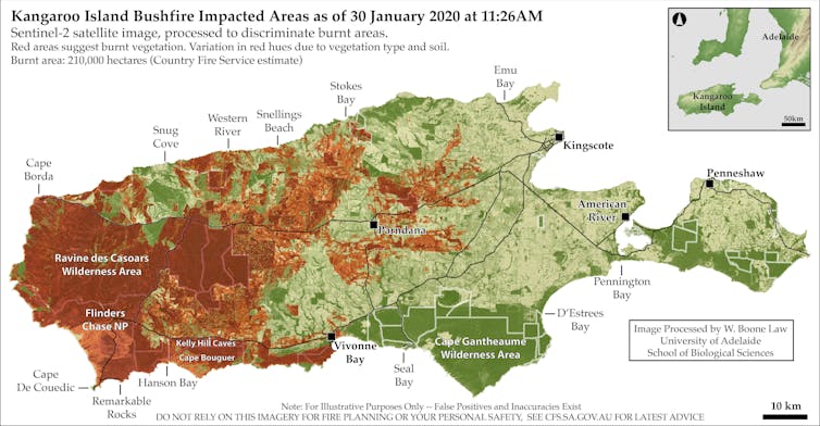
Processed Sentinel-2 satellite image. Red areas suggest burnt vegetation. Variation in red hues are caused by dominant vegetation type and soils. Sentinel-2/W. Boone Law, Author provided

National knowledge gap

My experience shows there is a swag of free and regularly updated satellite imagery available, which when interpreted and presented appropriately can potentially be hugely helpful to firefighting and recovery efforts.

However, I am concerned that neither the general public nor decision-makers seem fully aware of the range of satellite information on offer. Nor is there a good understanding of the advanced technical skills needed to access and process imagery into useful map data.

This leads me to wonder whether I have stumbled upon a glaring knowledge gap in Australia’s bushfire preparedness.

How can we overcome this technological and information bottleneck? I don’t propose to have all the answers, but I do believe it would be sensible for governments, industry and research agencies to invest in the kind of capabilities that I developed while trying to protect my own local community.

As Australia faces a future of more frequent and extreme bushfires, there will doubtless be many people who would be glad of this kind of information when they need it most.The Conversation

Wallace Boone Law, PhD Candidate, University of Adelaide

This article is republished from The Conversation under a Creative Commons license. Read the original article.

Editor's Picks

Spyre Group brings successful Queensland blueprint to Melbourne with Hampton Ltd
Saxon Street by Milieu to bring new housing and urban design to Brunswick’s cultural core
Construction begins at Fishermans Bend Innovation Precinct
Gurner reveals new plans for final Jam Factory stage
Tian An launches North Village, Auburn Square second stage

Related Projects

16-22 Maud Street, Newstead QLD 4006
Price
Contact agent
35-37 Mount Street, Prahran VIC 3181
Price
Contact agent
118-124 Benelong Road, Cremorne NSW 2090
Price
Contact agent
118-120 Matthew Flinders Drive, Cooee Bay QLD 4703
Price
Contact agent
26-62 Kinross Road, Thornlands QLD 4164
Price
Contact agent
9-11 Baroonba Street, Whitebridge NSW 2290
Price
Contact agent
18 Ransley Street, Penrith NSW 2750
Perle, East Side Quarter, Penrith - 18 Ransley Street, Penrith
18 Ransley Street, Penrith NSW 2750
Price
Contact agent
Ernest Cavanagh Street, Gungahlin ACT 2912
Raya, Gungahlin - Ernest Cavanagh Street, Gungahlin
Ernest Cavanagh Street, Gungahlin ACT 2912
Price
Contact agent
39 Browning Street, South Brisbane QLD 4101
39-41 Browning Street, South Brisbane - 39 Browning Street, South Brisbane
39 Browning Street, South Brisbane QLD 4101
Price
Contact agent
675 Gardeners Road, Mascot NSW 2020
Kiara North, Mascot - 675 Gardeners Road, Mascot
675 Gardeners Road, Mascot NSW 2020
Price
Contact agent
187 Salvado Road, Jolimont WA 6014
Jolie, Jolimont - 187 Salvado Road, Jolimont
187 Salvado Road, Jolimont WA 6014
Price
Contact agent
47 Maning Avenue, Sandy Bay TAS 7005
Grace Residences - 47 Maning Avenue, Sandy Bay
47 Maning Avenue, Sandy Bay TAS 7005
Price
Contact agent
Cove Lane, Narooma NSW 2546
Cove, Narooma - Cove Lane, Narooma
Cove Lane, Narooma NSW 2546
Price
Contact agent
52-56 Ramsay Street, Five Dock NSW 2046
Ava, Five Dock - 52-56 Ramsay Street, Five Dock
52-56 Ramsay Street, Five Dock NSW 2046
Price
Contact agent
2375 Gold Coast Highway, Mermaid Beach QLD 4218
The Alfred - 2375 Gold Coast Highway, Mermaid Beach
2375 Gold Coast Highway, Mermaid Beach QLD 4218
Price
Contact agent
129-131 Russell Ave, Dolls Point NSW 2219
ALLURE COLLECTION - 129-131 Russell Ave, Dolls Point
129-131 Russell Ave, Dolls Point NSW 2219
Price
Contact agent
62 Constitution Avenue, Parkes ACT 2600
The Eastbourne on Commonwealth Park - 62 Constitution Avenue, Parkes
62 Constitution Avenue, Parkes ACT 2600
Price
Contact agent
155 Old Burleigh Road, Broadbeach QLD 4218
Sandpiper, Broadbeach - 155 Old Burleigh Road, Broadbeach
155 Old Burleigh Road, Broadbeach QLD 4218
Price
Contact agent
33 Vulture Street, West End QLD 4101
Price
Contact agent
19 Governor Terrace, Murarrie QLD 4172
Park Hill Village Collection, Murarrie - 19 Governor Terrace, Murarrie
19 Governor Terrace, Murarrie QLD 4172
Price
Contact agent
122 Marine Parade, Miami QLD 4220
Nalu, Miami - 122 Marine Parade, Miami
122 Marine Parade, Miami QLD 4220
Price
Contact agent
34 Jacaranda Place, Indooroopilly QLD 4068
Price
Contact agent
167 Old Burleigh Road, Broadbeach QLD 4218
Price
Contact agent
21 Queens Way, Yeerongpilly QLD 4105
Yeerongpilly Green - 21 Queens Way, Yeerongpilly
21 Queens Way, Yeerongpilly QLD 4105
Price
Contact agent
445-449 River St, Ballina NSW 2478
Solhaven - 445-449 River St, Ballina
445-449 River St, Ballina NSW 2478
Price
Contact agent
52 Sunset Boulevard, Surfers Paradise QLD 4217
Price
Contact agent
6 Jack Brabham Drive, Hurstville NSW
Horizon Hurstville - 6 Jack Brabham Drive, Hurstville
6 Jack Brabham Drive, Hurstville NSW
Price
Contact agent
49 Seena Drive, Edgeworth NSW 2285
Price
Contact agent
Lot 118 Ocean Steamers Road, Port Adelaide SA 5015
Price
Contact agent
203 Ashmore Road, Benowa QLD 4217
Price
Contact agent
41 Warrs Road & 7 Horizon Drive, Maribyrnong VIC 3032
Price
Contact agent
774 Ripley Road, Ripley QLD 4306
Price
Contact agent
6 Homelea Court, Rivervale WA 6103
Price
Contact agent
7002 Ripley Road, Ripley QLD 4306
Price
Contact agent
136-148 Fox Valley Road, Wahroonga NSW 2076
Price
Contact agent
3 Delos Way, Sorrento WA 6020
Price
Contact agent
77 Sutton Street, Redcliffe QLD 4020
Price
Contact agent
119 Queen Street & 86 King Street, Bendigo VIC 3550
Price
Contact agent
181 Prospect Road, Prospect SA 5082
Price
Contact agent
593-595 Albany Highway, Victoria Park WA 6100
Price
Contact agent
1-28, 40 Civic Way, Rouse Hill NSW 2155
Price
Contact agent
93-97 Bay Street, Brighton VIC 3186
Price
Contact agent
22-38 & 27-31 The Avenue, Coburg VIC 3058
Price
Contact agent
1F Ashline Street, Wollert VIC 3750
Price
Contact agent
Lots 100 & 900 Kentucky Court, Cockburn Central WA 6164
Price
Contact agent
1260-1272 Malvern Road, Malvern VIC 3144
Price
Contact agent
472 Regency Road, Prospect SA 5082
Price
Contact agent
273A Gorge Road, Paradise SA 5075
273 Gorge Road, Paradise SA 5075 - 273A Gorge Road, Paradise
273A Gorge Road, Paradise SA 5075
Price
Contact agent
426-440 New South Head Road, Double Bay NSW 2028
Price
Contact agent
270 The Esplanade, Miami QLD 4220
Price
Contact agent